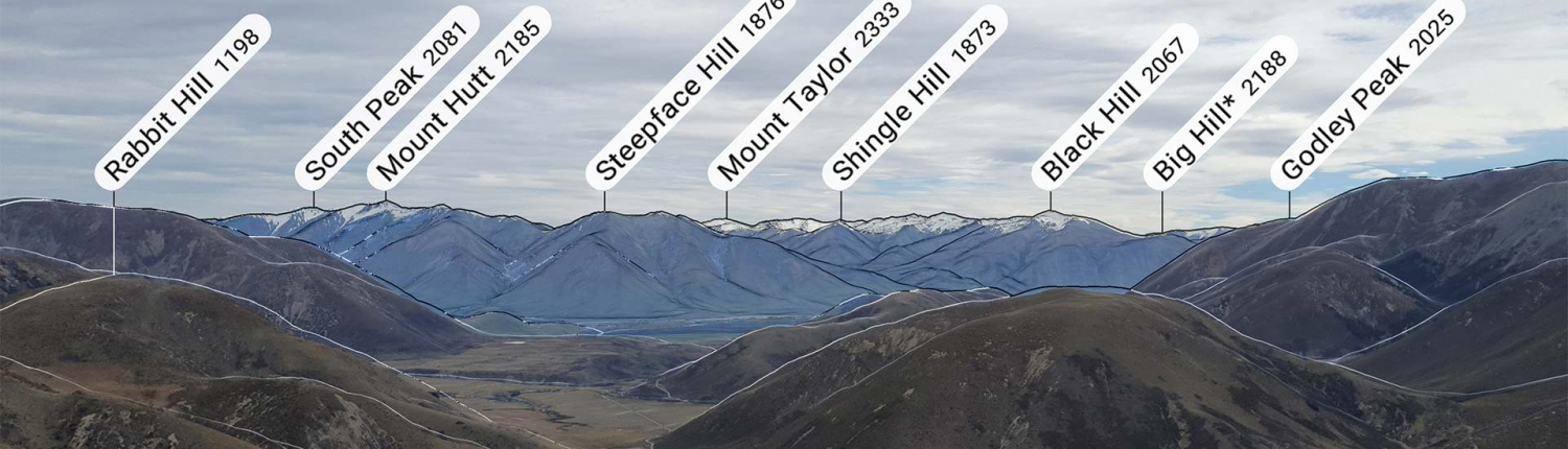
Identify Peaks with the PeakFinder App
At the top of Mt Richardson I met two guys who were visiting the area and trying to hit as many peaks as they could during their stay. They were pleased to meet a local (me) and, after I admitted to having been on some of the more popular summits in the area, they started firing questions at me about which peaks we could see laid out in front of us. I had no idea.
When I got home I realised there was probably an app that could help people like me that are relatively new to the area and/or go on a fair few solo hikes without the wise conversation of a local peak bagger, and that’s how I discovered the PeakFinder app. For identifying peaks, this app blew me away.
I’ve been using it for a while but recently shared it in a Tramping in New Zealand Facebook Group. The reactions from impressed hikers encourage me to give it a quick summary here to help others find it.
As an aside for those interested, I took this photo and video while standing on Trig ‘M’ in the Selwyn District of Canterbury, New Zealand. Just above Lake Lyndon.
The app uses AR (augmented reality) to display an overlay of peak labels for each peak in your camera’s view. There are additional overlays, such as a yellow line showing the path of the sun along with the a label for sunrise and sunset times. This would be awesome for setting up your tent to catch the sunrise in the morning, as well as for photography to ensure you catch the best light. It’ll also show the moon position for astrophotographers.
As you’ll see in the video above, you can also use the app offline when you get back home. Import a photo from your camera roll and, if the photo was taken on your phone with location enabled, the app will immediately jump to the right position and show you the visible peaks. Don’t worry if location wasn’t enabled – you can just tell it where it was taken and it’ll give you a similar result.

There is a small one-off charge for the app, but it’s well worth it if you head into the hills often.
 https://nzraw.co.nz/wp-content/uploads/2024/07/mackintosh-beach-waipara-walks-10.jpg
1067
1600
Mark
https://nzraw.co.nz/wp-content/uploads/2020/06/nz-raw-logo.png
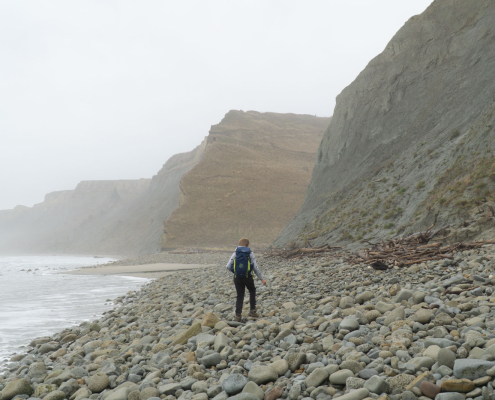
Mark2024-07-21 15:34:162024-07-21 15:54:27MacKintosh Beach Family Walk Near Waipara, North Canterbury
https://nzraw.co.nz/wp-content/uploads/2024/07/mackintosh-beach-waipara-walks-10.jpg
1067
1600
Mark
https://nzraw.co.nz/wp-content/uploads/2020/06/nz-raw-logo.png
Mark2024-07-21 15:34:162024-07-21 15:54:27MacKintosh Beach Family Walk Near Waipara, North Canterbury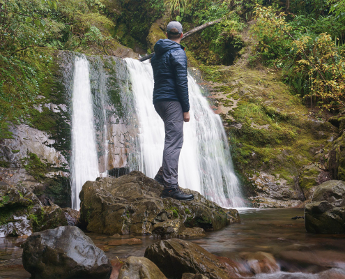 https://nzraw.co.nz/wp-content/uploads/2023/06/picture-takashima-jacket-review-new-zealand.jpg
908
1210
Mark
https://nzraw.co.nz/wp-content/uploads/2020/06/nz-raw-logo.png
Mark2023-06-30 08:57:142023-06-30 08:57:14Review of the Picture Takashima Jacket
https://nzraw.co.nz/wp-content/uploads/2023/06/picture-takashima-jacket-review-new-zealand.jpg
908
1210
Mark
https://nzraw.co.nz/wp-content/uploads/2020/06/nz-raw-logo.png
Mark2023-06-30 08:57:142023-06-30 08:57:14Review of the Picture Takashima Jacket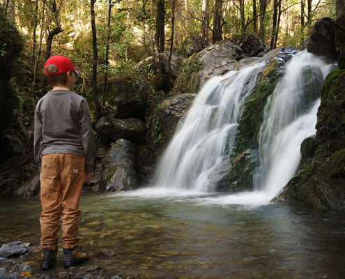 https://nzraw.co.nz/wp-content/uploads/2023/01/waterfalls-nz-800x600-1.jpg
600
800
Mark
https://nzraw.co.nz/wp-content/uploads/2020/06/nz-raw-logo.png
Mark2023-01-06 16:46:302023-01-11 13:30:04Best Family Friendly Waterfalls of Mid-South Island New Zealand
https://nzraw.co.nz/wp-content/uploads/2023/01/waterfalls-nz-800x600-1.jpg
600
800
Mark
https://nzraw.co.nz/wp-content/uploads/2020/06/nz-raw-logo.png
Mark2023-01-06 16:46:302023-01-11 13:30:04Best Family Friendly Waterfalls of Mid-South Island New Zealand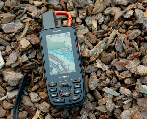 https://nzraw.co.nz/wp-content/uploads/2022/04/garmin-66i-gps-showing-map.jpg
806
1210
Mark
https://nzraw.co.nz/wp-content/uploads/2020/06/nz-raw-logo.png
Mark2022-04-23 16:15:202023-06-28 13:41:39Why I chose a Garmin 66i inReach GPS device
https://nzraw.co.nz/wp-content/uploads/2022/04/garmin-66i-gps-showing-map.jpg
806
1210
Mark
https://nzraw.co.nz/wp-content/uploads/2020/06/nz-raw-logo.png
Mark2022-04-23 16:15:202023-06-28 13:41:39Why I chose a Garmin 66i inReach GPS device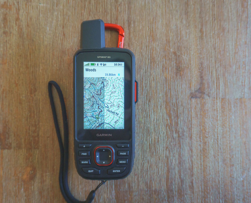 https://nzraw.co.nz/wp-content/uploads/2022/04/garmin-66i-showing-new-zealand-topo-50-maps-1.jpg
806
1210
Mark
https://nzraw.co.nz/wp-content/uploads/2020/06/nz-raw-logo.png
Mark2022-04-09 12:12:282022-04-23 16:08:42How to add NZ topo maps to a Garmin GPS device (for free)
https://nzraw.co.nz/wp-content/uploads/2022/04/garmin-66i-showing-new-zealand-topo-50-maps-1.jpg
806
1210
Mark
https://nzraw.co.nz/wp-content/uploads/2020/06/nz-raw-logo.png
Mark2022-04-09 12:12:282022-04-23 16:08:42How to add NZ topo maps to a Garmin GPS device (for free)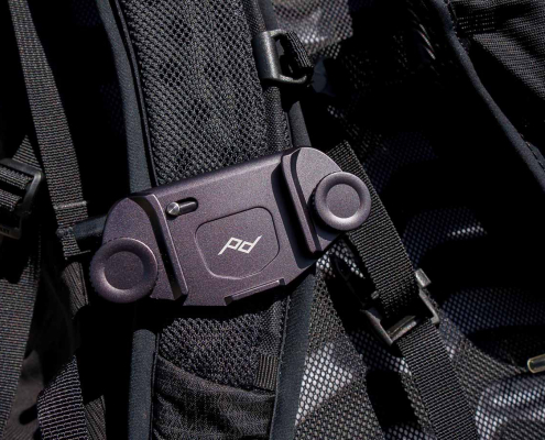 https://nzraw.co.nz/wp-content/uploads/2022/01/review-peak-design-capture-clip-v3.jpg
908
1210
Mark
https://nzraw.co.nz/wp-content/uploads/2020/06/nz-raw-logo.png
Mark2022-01-08 16:08:332022-04-09 08:37:28Peak Design Capture Clip v3 Review
https://nzraw.co.nz/wp-content/uploads/2022/01/review-peak-design-capture-clip-v3.jpg
908
1210
Mark
https://nzraw.co.nz/wp-content/uploads/2020/06/nz-raw-logo.png
Mark2022-01-08 16:08:332022-04-09 08:37:28Peak Design Capture Clip v3 Review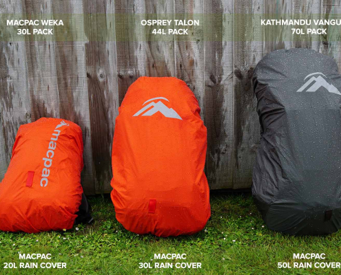 https://nzraw.co.nz/wp-content/uploads/2021/11/macpac-rain-covers-on-packs.jpg
1067
1600
Mark
https://nzraw.co.nz/wp-content/uploads/2020/06/nz-raw-logo.png
Mark2021-11-13 18:07:322022-04-09 08:37:40Macpac Waterproof Pack Cover Sizing
https://nzraw.co.nz/wp-content/uploads/2021/11/macpac-rain-covers-on-packs.jpg
1067
1600
Mark
https://nzraw.co.nz/wp-content/uploads/2020/06/nz-raw-logo.png
Mark2021-11-13 18:07:322022-04-09 08:37:40Macpac Waterproof Pack Cover Sizing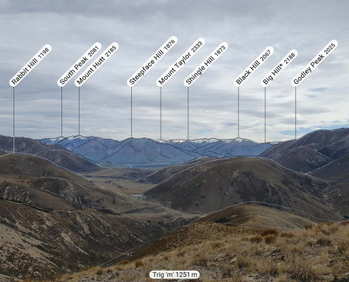 https://nzraw.co.nz/wp-content/uploads/2021/10/app-for-identifying-peaks.jpg
908
1210
Mark
https://nzraw.co.nz/wp-content/uploads/2020/06/nz-raw-logo.png
Mark2021-10-24 09:24:542022-04-09 08:37:53Identify Peaks with the PeakFinder App
https://nzraw.co.nz/wp-content/uploads/2021/10/app-for-identifying-peaks.jpg
908
1210
Mark
https://nzraw.co.nz/wp-content/uploads/2020/06/nz-raw-logo.png
Mark2021-10-24 09:24:542022-04-09 08:37:53Identify Peaks with the PeakFinder App https://nzraw.co.nz/wp-content/uploads/2021/07/mt-thomas-walk-canterbury-08.jpg
900
1600
Mark
https://nzraw.co.nz/wp-content/uploads/2020/06/nz-raw-logo.png
Mark2021-07-18 12:47:582021-07-18 12:50:53Mount Thomas Walk in North Canterbury
https://nzraw.co.nz/wp-content/uploads/2021/07/mt-thomas-walk-canterbury-08.jpg
900
1600
Mark
https://nzraw.co.nz/wp-content/uploads/2020/06/nz-raw-logo.png
Mark2021-07-18 12:47:582021-07-18 12:50:53Mount Thomas Walk in North Canterbury